Using caveDB
Documentation
Table of Contents
caveDB is currently in beta and under active development. Some features may differ between the documentation and the app and features are subject to change at any time although all data will be preserved
User interface
Title bar controls
| Open main menu | Access tools and settings | |
| Import media | Contribute photos, videos, survey and other files Go to docs |
|
| Show recent changes | See the latest updates to the database Go to docs |
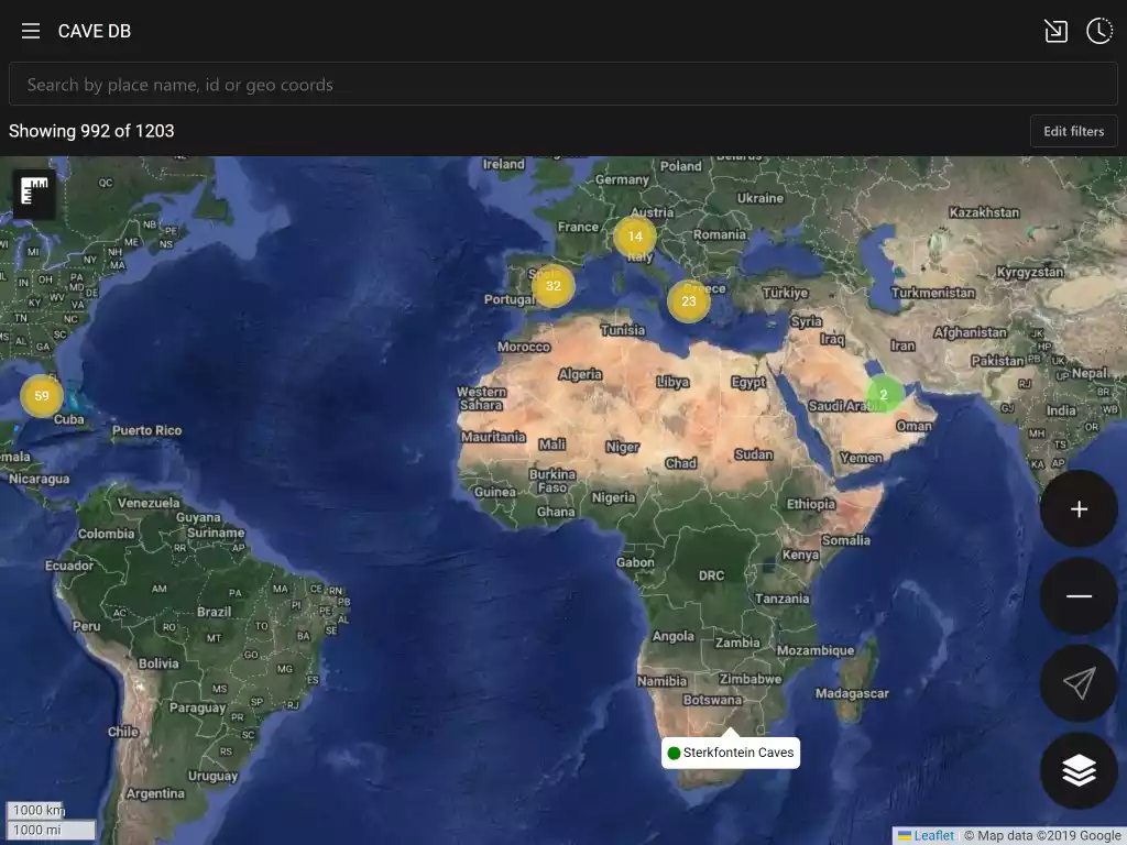
Search bar
The search bar allows to you to search by place name or id or to go to a given set of coordinates. Geo coordinates can be in many formats, for instance :-
- 40.123, -74.123
- 40.123° N 74.123° W
- 40° 7´ 22.8” N 74° 7´ 22.8” W
- …
Full list of supported geo coordinate formats
Map controls
| Zoom in | Zoom the map in | |
| Zoom out | Zoom the map out | |
| Track current location | Zooms map to your current location and tracks as you move | |
| Change map type | Select between satellite and terrain maps | |
| Zoom to filter | Zoom the map to show all sites visible with the current filter | |
| Measure distance on the map | Click to enable and select points on the map to measure between. You can add multiple points. Click again to stop measuring |
Filtering
By default caveDB will filter out many areas that may interest you. You can see how many it could potentially show you by the Showing X of Y text under the search bar. This will also be filtered by any text that you have in the search bar. To edit the filter click the Edit filter button to open the filter editor.
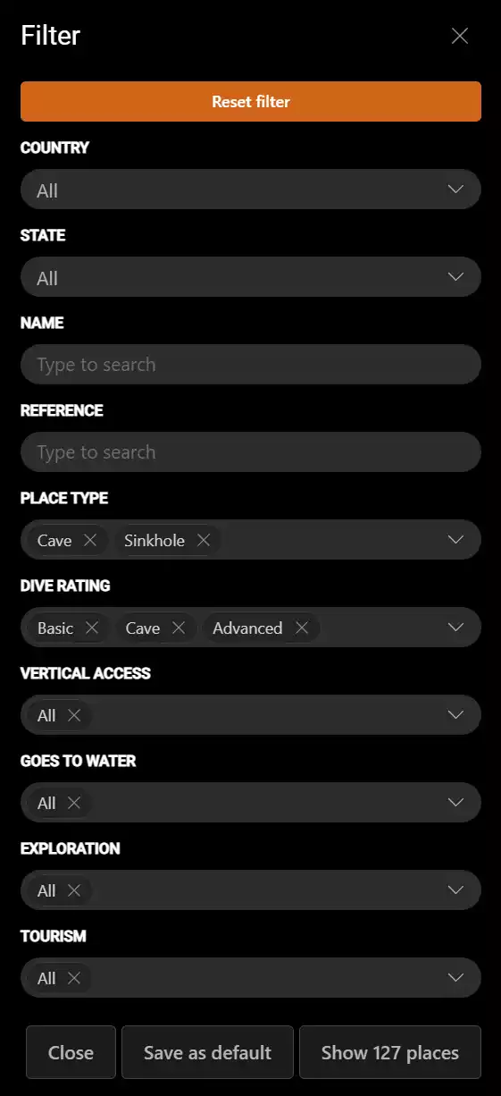
Here you can adjust the filter to drill down into the sites that you are interested in. To reset back to your default filter click Reset Filter. To save the current filter as your default filter click Save as default. The Show button will display how many sites your current filter will show and on clicking will apply the filter and return to the map. Click the Close button to exit without applying any changes.
Site information
Click the map marker to view details about that site.
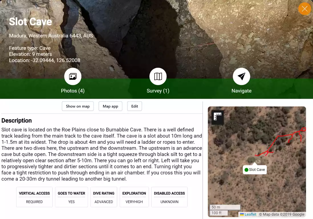
Commands
| Open the media gallery | |
| View survey data | |
| Start navigation see navigation |
|
| Show on Map | Go to the site location on the map |
| Map app | Open the device map application and start navigating |
| Edit | Only visible if you have permission to edit the site |
| Add trip report | Add a trip report to the site including rating |
Displayed properties
| Type | The type of this feature see feature types |
| Elevation | Height above sea level |
| Location | Location in decimal degrees using the WGS84 datum |
| Reference | Arbitrary reference. Commonly a karst index |
| Vertical access | You will require ropes or ladders to enter this site. Seek proper training beforehand. |
| Goes to water | Does this cave lead to fresh water |
| Dive rating | The dive ratings you must have to dive this site. The site may have multiple rating so make sure you check the site details and only access areas your training allows see site ratings |
| Exploration | How much exploration potential does this site has |
| Disabled access | How much potential this site has to allow disabled access of some kind |
| Water temp | Temperature range of the water |
Dive ratings
| Basic cave | Cavern region only |
| Cave | Penetration with no restrictions that you cannot pass side by side whilst air sharing |
| Advanced cave | Penetration with restrictions. Each site will need to be researched individually as they may contain tight restrictions and heavy silt |
Feature types
| Unknown | Needs on ground investigation |
| Not found | Could not be found at the location |
| Landmark | General non cave feature landmark |
| Destroyed | A feature that previously existed has been destroyed |
| Depression | A depression may be quite large and does not have any visible entrances |
| Cave | A cave is a natural underground chamber in a hillside or cliff or a natural void in the ground, specifically a space large enough for a human to enter |
| Sinkhole | A hole in the ground that forms when water dissolves surface rock, especially limestone, and causes the ground above to collapse. Sinkholes can vary in size and depth, and can be natural or human-made |
| Solution tube | A geological solution tube is a vertical cylindrical hole in limestone or other soluble rock, formed by the dissolution of the rock by water. It is a type of karst feature that can be found in regions with humid climates and abundant rainfall. Solution tubes can vary in diameter and depth, and may contain sediments, fossils, or cave formations |
| Mine | Disused mine, likely flooded |
Account
Creating an account allows to contribute to the database as well other features.
Creating an account
- Click the
 button at the top left of the screen to open the main menu
 - Click the
Sign upbutton underCloud settings
You will be prompted for your email address and a password.
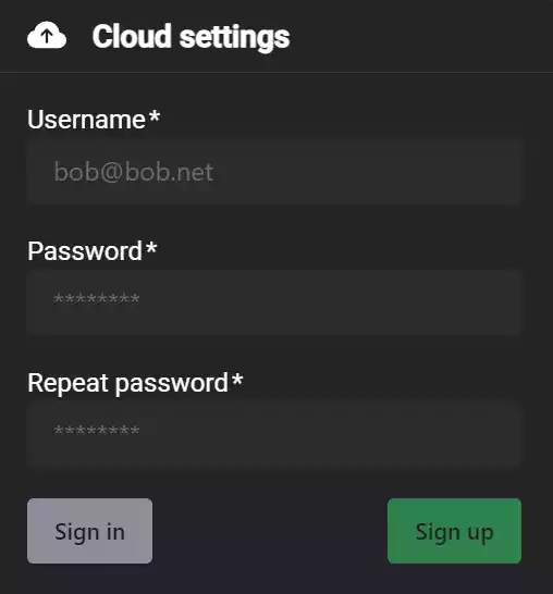
Your password must be at least 8 characters long
When you have enter the information click the Sign up button. You will be emailed a verification code to your email address that you will need to verify your email address.
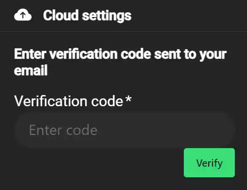
Enter the verification code and click verify to complete creating your account and login.
Forgotten password
- Click the button at the top left of the screen to open the main menu.
- Click the
Forgot passwordbutton underCloud settings - Enter your email address you signed up with to receive a reset code
- Enter your email address, reset code and the new password to use
Tools
Tools are available by clicking ![]() at the top left of the screen.
at the top left of the screen.
Go to location
Center the map on a set of geo coordinates give in decimal degrees, DMS or text string
Create a new place
Contribute a new place to the database. This can also be open by long clicking on the map where you want to create the place.
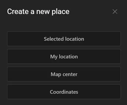
| Selected location | Use the location of the long click on the map |
| My location | Add a place at your current GPS location |
| Map center | Add a place at the current map center location |
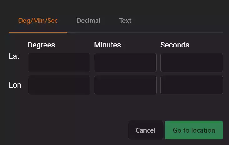
| Coordinates | Add a place at a specific set of geo coordinates in decimal degrees, degrees/minutes/seconds and text formats Supported text formats |
Export to GPX
Exports the currently filtered places to GPS format so you can import it to your handheld GPS tracker. It currently supports the following GPX export file types.
| Standard | Single large GPX file |
| Garmin | This exports in a format that garmin devices can use. Garmin import is limited to 500 place marks so this will output multiple files if necessary |
| Strava | Single large GPX file for Strava |
Settings
Click the ![]() button at the top left of the screen to open the main menu and scroll to
button at the top left of the screen to open the main menu and scroll to User settings
| Display name | This is the name other users will see your contributions as. |
| Navigation sensitivity | Degrees of deviation from the site direction to show as straight ahead |
| Show compass | Show the compass on the main map |
| Enable tile cache | Enable reading and writing map tiles to a local cache. You will need to enable this when out of mobile signal. Currently is has a performance impact so is not enabled by default |
| Logging level | Set logging to the developer console. Generally do not change unless asked to assist in debugging. You must reload the page for it take effect |
| Units | Set display units to imperial or metric |
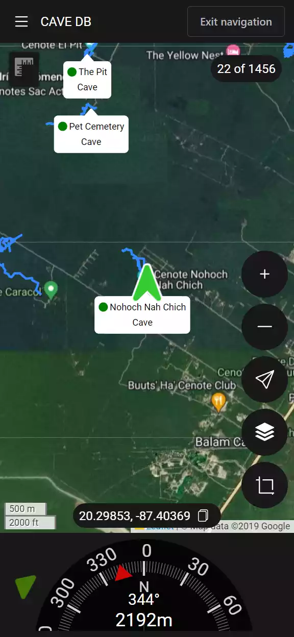
Navigator
To help find a site on the ground you can use the built in navigation. To enable navigation open the place and click ![]() . This will start navigation mode and you will now see a compass at the bottom of the screen. To exit navigation click the
. This will start navigation mode and you will now see a compass at the bottom of the screen. To exit navigation click the Exit navigation button at the top right of the screen.
This shows you the current distance to the location and the bearing from your current orientation. The arrows to the left and right direct you as to which way to turn and will show two arrows pointing forward when you are heading in the correct direction. Best results can be achieved by calibrating your phone compass on site.
Survey
Survey data can be added to any place using the media upload feature. This allows you to upload KML, GPX and GeoJSON files that will be displayed on the map.
Using offline
caveDB is built to work when you are in the field and out of mobile or internet connection. All contributions to places made when you are offline will automatically synchronized when you are back in signal. Unlike place information you need to explicitly download maps and place media so you can use them when offline.
While the data is downloading the app must be open. It will restart if you close the app but it can take a significant amount of time to download large amounts of map tiles
Caching map tiles
- Zoom the map to the area of the map that you want to download map tiles for
- Click the button at the top left of the screen to open the main menu
- Click
Going offlineunder tools - Select the
Viewporttab - Choose which map type you want to download and the maximum zoom level
- Click
Cache tiles
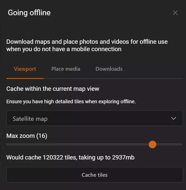
The higher the zoom level the more space it will need and you will hit maximum download limits (currently 4GB). If you see a warning the the current settings exceed the cache size limit you need to either reduce the max zoom level or close the dialog and zoom in on the map further.
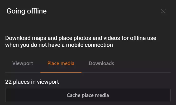
Caching place media
This will download all photos, videos and survey data so you can view it while offline.
- Zoom the map to the area of the map that you want to download map tiles for
- Click the button at the top left of the screen to open the main menu
- Click
Going offlineunder tools - Select the
Place mediatab - Click
Cache place media
Contributing
Contribute a new place to the database. This can also be open by long clicking on the map where you want to create the place.
| Selected location | Use the location of the long click on the map |
| My location | Add a place at your current GPS location |
| Map center | Add a place at the current map center location |
| Coordinates | Add a place at a specific set of geo coordinates in decimal degrees, degrees/minutes/seconds and text formats Supported text formats |
Media import
Unless you are an editor the media will be queued until it has been check for relevance and approved.
Each place has associated media that users can contribute to which includes photos, videos, survey data, documents and YouTube videos.
You can open the media import by clicking ![]() on the right of the title bar. This opens a drawer that allows to you import multiple items at once. For photos it will read any GPS data attached to the photo to guess the place it is related.
on the right of the title bar. This opens a drawer that allows to you import multiple items at once. For photos it will read any GPS data attached to the photo to guess the place it is related.
Selecting files to import
- Click
Browse for files - Select files to import
Selecting the place for an item
- Click
Select place - Select the place on the map
- Click
Acceptto add the item to the place - Click
Discardto remove the item from the import
Adding directly to a site
- Go the place on the map
- Click it to open the place details view
- Click
Add mediato open the media importer - Select media to import
- Review and upload or discard.
Adding YouTube videos to a site
You will need the link to the
- Go the place on the map
- Click it to open the place details view
- Click
editto open the place editor - Click
Add YouTube linkat the top of the edit screen. - Enter URL to YouTube video
- Click
Accept - Click
Save
Supported file types
| SVG | .svg |
These are preferred where possible over image formats |
| Images | .png, .jpg, .gif |
Photos and other images. Must be under 8mb |
| Videos | .mp4 |
Videos. Must be under 50mb |
| GeoJSON | .json |
Survey data in GeoJSON format |
| KML | .kml |
Survey data in KML format |
| YouTube | url |
Url from YouTube share dialog e.g https://www.youtube.com/watch?v=KImaj-zfgE4 |
Appendix
Supported geocoords formats
- 40.123, -74.123
- 40.123° N 74.123° W
- 40° 7´ 22.8” N 74° 7´ 22.8” W
- 40° 7.38’ , -74° 7.38’
- N40°7’22.8, W74°7’22.8”
- 40°7’22.8”N, 74°7’22.8”W
- 40 7 22.8, -74 7 22.8
- 40.123 -74.123
- 40.123°,-74.123°
- 144442800, -266842800
- 40.123N74.123W
- 4007.38N7407.38W
- 40°7’22.8”N, 74°7’22.8”W
- 400722.8N740722.8W
- N 40 7.38 W 74 7.38
- 40:7:23N,74:7:23W
- 40:7:22.8N 74:7:22.8W
- 40°7’23”N 74°7’23”W
- 40°7’23” -74°7’23”
- 40d 7’ 23” N 74d 7’ 23” W
- 40.123N 74.123W
- 40° 7.38, -74° 7.38
JSON schema for bulk importing
The JSON schema for the database can be downloaded here